|
|
|||||||||||||||||
| Point ID: 9634 | Downloads | Plots | Site Data | Code: 05077700 |
|
|
|||||||||||||||||
| Download | |
|---|---|
| Site Descriptor Information | Site Time Series Data |
| Link to all available data | |
| View: | Time Series | All |
| Units: | mm |
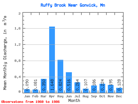
| Statistic | Jan | Feb | Mar | Apr | May | Jun | Jul | Aug | Sep | Oct | Nov | Dec | Annual |
|---|---|---|---|---|---|---|---|---|---|---|---|---|---|
| Mean | 0.09 | 0.08 | 0.35 | 1.65 | 0.82 | 0.52 | 0.26 | 0.11 | 0.19 | 0.22 | 0.20 | 0.13 | 0.40 |
| Standard Deviation | 0.06 | 0.05 | 0.34 | 0.88 | 0.63 | 0.48 | 0.39 | 0.11 | 0.36 | 0.26 | 0.20 | 0.10 | 0.15 |
| Min | 0.01 | 0.01 | 0.06 | 0.20 | 0.13 | 0.07 | 0.06 | 0.03 | 0.02 | 0.03 | 0.04 | 0.01 | 0.18 |
| Max | 0.26 | 0.21 | 1.06 | 3.35 | 2.97 | 1.54 | 1.62 | 0.53 | 1.68 | 0.98 | 0.89 | 0.39 | 0.73 |
| Coefficient of Variation | 0.69 | 0.64 | 0.97 | 0.53 | 0.77 | 0.93 | 1.47 | 1.04 | 1.94 | 1.15 | 1.00 | 0.76 | 0.38 |
 Return to R-Arctic Net Home Page