|
|
|||||||||||||||||
| Point ID: 9618 | Downloads | Plots | Site Data | Code: 05077500 |
|
|
|||||||||||||||||
| Download | |
|---|---|
| Site Descriptor Information | Site Time Series Data |
| Link to all available data | |
| View: | Time Series | All |
| Units: | mm |
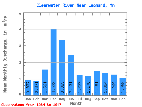
| Statistic | Jan | Feb | Mar | Apr | May | Jun | Jul | Aug | Sep | Oct | Nov | Dec | Annual |
|---|---|---|---|---|---|---|---|---|---|---|---|---|---|
| Mean | 0.94 | 0.87 | 1.56 | 4.02 | 3.37 | 2.43 | 1.23 | 1.18 | 1.48 | 1.36 | 1.27 | 1.06 | 1.68 |
| Standard Deviation | 0.22 | 0.25 | 1.44 | 2.31 | 1.54 | 1.54 | 0.54 | 0.82 | 0.98 | 0.77 | 0.51 | 0.32 | 0.56 |
| Min | 0.56 | 0.48 | 0.35 | 1.62 | 1.52 | 0.73 | 0.43 | 0.17 | 0.27 | 0.57 | 0.72 | 0.69 | 1.03 |
| Max | 1.36 | 1.39 | 5.05 | 10.27 | 6.67 | 6.21 | 2.31 | 3.24 | 3.35 | 2.47 | 2.34 | 1.80 | 2.61 |
| Coefficient of Variation | 0.23 | 0.28 | 0.92 | 0.57 | 0.46 | 0.63 | 0.44 | 0.70 | 0.66 | 0.57 | 0.40 | 0.30 | 0.33 |
 Return to R-Arctic Net Home Page