|
|
|||||||||||||||||
| Point ID: 9613 | Downloads | Plots | Site Data | Code: 05047500 |
|
|
|||||||||||||||||
| Download | |
|---|---|
| Site Descriptor Information | Site Time Series Data |
| Link to all available data | |
| View: | Time Series | All |
| Units: | mm |
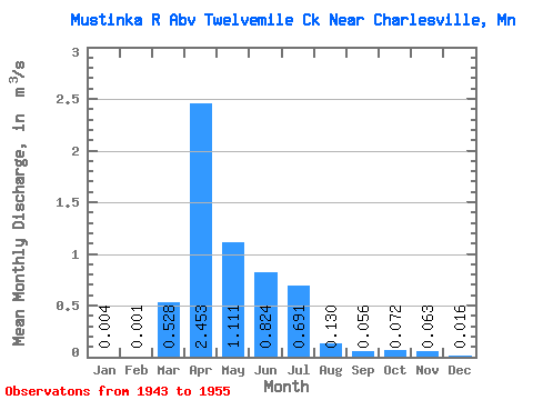
| Statistic | Jan | Feb | Mar | Apr | May | Jun | Jul | Aug | Sep | Oct | Nov | Dec | Annual |
|---|---|---|---|---|---|---|---|---|---|---|---|---|---|
| Mean | 0.00 | 0.00 | 0.53 | 2.45 | 1.11 | 0.82 | 0.69 | 0.13 | 0.06 | 0.07 | 0.06 | 0.02 | 0.50 |
| Standard Deviation | 0.01 | 0.00 | 0.74 | 2.64 | 1.21 | 0.79 | 0.84 | 0.19 | 0.07 | 0.07 | 0.05 | 0.02 | 0.28 |
| Min | 0.00 | 0.00 | 0.00 | 0.36 | 0.05 | 0.09 | 0.07 | 0.01 | 0.00 | 0.00 | 0.01 | 0.00 | 0.17 |
| Max | 0.02 | 0.01 | 2.21 | 8.81 | 4.33 | 2.53 | 3.14 | 0.72 | 0.24 | 0.22 | 0.15 | 0.06 | 1.01 |
| Coefficient of Variation | 2.01 | 2.01 | 1.40 | 1.08 | 1.09 | 0.96 | 1.21 | 1.47 | 1.20 | 1.05 | 0.80 | 1.26 | 0.56 |
 Return to R-Arctic Net Home Page