|
|
|||||||||||||||||
| Point ID: 9609 | Downloads | Plots | Site Data | Code: 05059480 |
|
|
|||||||||||||||||
| Download | |
|---|---|
| Site Descriptor Information | Site Time Series Data |
| Link to all available data | |
| View: | Time Series | All |
| Units: | mm |
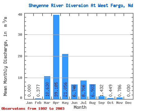
| Statistic | Jan | Feb | Mar | Apr | May | Jun | Jul | Aug | Sep | Oct | Nov | Dec | Annual |
|---|---|---|---|---|---|---|---|---|---|---|---|---|---|
| Mean | 0.00 | 0.38 | 10.63 | 39.19 | 21.06 | 6.75 | 8.71 | 6.90 | 1.43 | 0.45 | 0.79 | 0.03 | 8.79 |
| Standard Deviation | 0.00 | 0.83 | 12.67 | 36.71 | 28.20 | 7.53 | 9.45 | 18.08 | 2.49 | 1.07 | 1.48 | 0.10 | 5.28 |
| Min | 0.00 | 0.00 | 0.00 | 0.00 | 0.00 | 0.00 | 0.03 | 0.00 | 0.00 | 0.00 | 0.00 | 0.00 | 0.12 |
| Max | 0.00 | 2.55 | 31.45 | 93.11 | 83.16 | 23.62 | 28.33 | 60.72 | 8.26 | 3.61 | 3.90 | 0.33 | 15.12 |
| Coefficient of Variation | 2.20 | 1.19 | 0.94 | 1.34 | 1.12 | 1.09 | 2.62 | 1.74 | 2.39 | 1.89 | 3.32 | 0.60 |
 Return to R-Arctic Net Home Page