|
|
|||||||||||||||||
| Point ID: 9607 | Downloads | Plots | Site Data | Code: 05059300 |
|
|
|||||||||||||||||
| Download | |
|---|---|
| Site Descriptor Information | Site Time Series Data |
| Link to all available data | |
| View: | Time Series | All |
| Units: | mm |
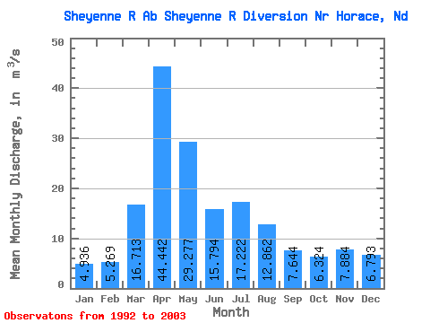
| Statistic | Jan | Feb | Mar | Apr | May | Jun | Jul | Aug | Sep | Oct | Nov | Dec | Annual |
|---|---|---|---|---|---|---|---|---|---|---|---|---|---|
| Mean | 4.94 | 5.27 | 16.71 | 44.44 | 29.28 | 15.79 | 17.22 | 12.86 | 7.64 | 6.32 | 7.88 | 6.79 | 15.51 |
| Standard Deviation | 1.83 | 2.31 | 12.17 | 31.75 | 23.50 | 6.15 | 8.42 | 16.89 | 5.65 | 4.70 | 5.12 | 3.12 | 4.78 |
| Min | 2.07 | 1.73 | 1.73 | 4.42 | 6.58 | 7.13 | 8.19 | 2.59 | 1.76 | 1.50 | 1.55 | 0.90 | 4.71 |
| Max | 7.58 | 8.57 | 34.38 | 83.93 | 77.50 | 26.79 | 32.77 | 62.88 | 16.49 | 19.05 | 17.48 | 12.16 | 20.96 |
| Coefficient of Variation | 0.37 | 0.44 | 0.73 | 0.71 | 0.80 | 0.39 | 0.49 | 1.31 | 0.74 | 0.74 | 0.65 | 0.46 | 0.31 |
 Return to R-Arctic Net Home Page