|
|
|||||||||||||||||
| Point ID: 9598 | Downloads | Plots | Site Data | Code: 05127205 |
|
|
|||||||||||||||||
| Download | |
|---|---|
| Site Descriptor Information | Site Time Series Data |
| Link to all available data | |
| View: | Time Series | All |
| Units: | mm |
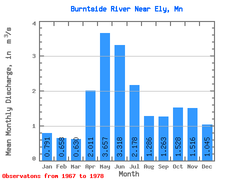
| Statistic | Jan | Feb | Mar | Apr | May | Jun | Jul | Aug | Sep | Oct | Nov | Dec | Annual |
|---|---|---|---|---|---|---|---|---|---|---|---|---|---|
| Mean | 0.79 | 0.66 | 0.63 | 2.01 | 3.66 | 3.32 | 2.18 | 1.29 | 1.26 | 1.53 | 1.52 | 1.04 | 1.70 |
| Standard Deviation | 0.56 | 0.43 | 0.32 | 1.16 | 1.64 | 1.94 | 0.82 | 0.80 | 1.52 | 1.76 | 1.44 | 0.94 | 0.47 |
| Min | 0.00 | 0.00 | 0.01 | 0.01 | 0.10 | 1.19 | 1.25 | 0.38 | 0.01 | 0.00 | 0.00 | 0.00 | 0.78 |
| Max | 1.49 | 1.27 | 1.04 | 3.88 | 5.62 | 7.52 | 3.94 | 3.14 | 5.46 | 4.94 | 3.78 | 2.69 | 2.50 |
| Coefficient of Variation | 0.71 | 0.65 | 0.51 | 0.58 | 0.45 | 0.59 | 0.38 | 0.62 | 1.20 | 1.15 | 0.95 | 0.90 | 0.28 |
 Return to R-Arctic Net Home Page