|
|
|||||||||||||||||
| Point ID: 9595 | Downloads | Plots | Site Data | Code: 05055000 |
|
|
|||||||||||||||||
| Download | |
|---|---|
| Site Descriptor Information | Site Time Series Data |
| Link to all available data | |
| View: | Time Series | All |
| Units: | mm |
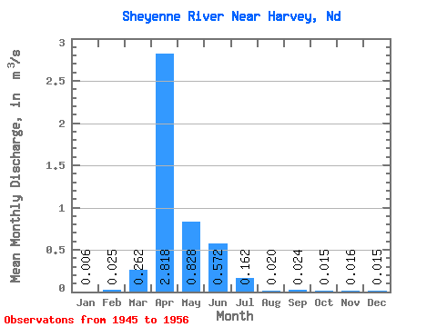
| Statistic | Jan | Feb | Mar | Apr | May | Jun | Jul | Aug | Sep | Oct | Nov | Dec | Annual |
|---|---|---|---|---|---|---|---|---|---|---|---|---|---|
| Mean | 0.01 | 0.03 | 0.26 | 2.82 | 0.83 | 0.57 | 0.16 | 0.02 | 0.02 | 0.01 | 0.02 | 0.01 | 0.40 |
| Standard Deviation | 0.01 | 0.08 | 0.25 | 2.90 | 1.63 | 0.71 | 0.21 | 0.04 | 0.05 | 0.03 | 0.03 | 0.02 | 0.37 |
| Min | 0.00 | 0.00 | 0.01 | 0.20 | 0.03 | 0.01 | 0.03 | 0.00 | 0.00 | 0.00 | 0.00 | 0.00 | 0.08 |
| Max | 0.05 | 0.25 | 0.68 | 9.18 | 5.68 | 2.44 | 0.77 | 0.15 | 0.16 | 0.09 | 0.07 | 0.05 | 1.34 |
| Coefficient of Variation | 2.57 | 3.03 | 0.95 | 1.03 | 1.97 | 1.25 | 1.28 | 2.20 | 2.12 | 1.91 | 1.50 | 1.32 | 0.92 |
 Return to R-Arctic Net Home Page