|
|
|||||||||||||||||
| Point ID: 9592 | Downloads | Plots | Site Data | Code: 05123750 |
|
|
|||||||||||||||||
| Download | |
|---|---|
| Site Descriptor Information | Site Time Series Data |
| Link to all available data | |
| View: | Time Series | All |
| Units: | mm |
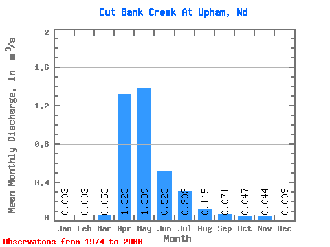
| Statistic | Jan | Feb | Mar | Apr | May | Jun | Jul | Aug | Sep | Oct | Nov | Dec | Annual |
|---|---|---|---|---|---|---|---|---|---|---|---|---|---|
| Mean | 0.00 | 0.00 | 0.05 | 1.32 | 1.39 | 0.52 | 0.30 | 0.12 | 0.07 | 0.05 | 0.04 | 0.01 | 0.46 |
| Standard Deviation | 0.01 | 0.01 | 0.09 | 2.65 | 2.24 | 1.06 | 0.65 | 0.22 | 0.14 | 0.09 | 0.09 | 0.02 | 0.48 |
| Min | 0.00 | 0.00 | 0.00 | 0.00 | 0.00 | 0.00 | 0.00 | 0.00 | 0.00 | 0.00 | 0.00 | 0.00 | 0.00 |
| Max | 0.02 | 0.03 | 0.29 | 8.48 | 6.42 | 3.31 | 2.22 | 0.79 | 0.47 | 0.22 | 0.23 | 0.04 | 0.98 |
| Coefficient of Variation | 2.38 | 3.00 | 1.76 | 2.00 | 1.62 | 2.04 | 2.14 | 1.91 | 1.92 | 1.86 | 2.10 | 1.78 | 1.06 |
 Return to R-Arctic Net Home Page