|
|
|||||||||||||||||
| Point ID: 9513 | Downloads | Plots | Site Data | Code: 15282000 |
|
|
|||||||||||||||||
| Download | |
|---|---|
| Site Descriptor Information | Site Time Series Data |
| Link to all available data | |
| View: | Time Series | All |
| Units: | mm |
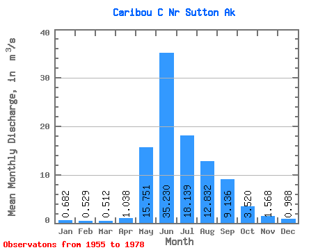
| Statistic | Jan | Feb | Mar | Apr | May | Jun | Jul | Aug | Sep | Oct | Nov | Dec | Annual |
|---|---|---|---|---|---|---|---|---|---|---|---|---|---|
| Mean | 0.68 | 0.53 | 0.51 | 1.04 | 15.75 | 35.23 | 18.14 | 12.83 | 9.14 | 3.52 | 1.57 | 0.99 | 8.52 |
| Standard Deviation | 0.44 | 0.33 | 0.33 | 0.62 | 8.95 | 15.67 | 7.21 | 6.44 | 4.57 | 0.96 | 0.66 | 0.52 | 2.44 |
| Min | 0.03 | 0.03 | 0.01 | 0.07 | 2.97 | 8.00 | 3.81 | 4.73 | 3.98 | 2.17 | 0.47 | 0.09 | 3.87 |
| Max | 1.35 | 0.99 | 0.91 | 2.75 | 46.41 | 74.18 | 36.11 | 26.33 | 21.01 | 5.94 | 3.27 | 2.00 | 13.60 |
| Coefficient of Variation | 0.64 | 0.63 | 0.64 | 0.60 | 0.57 | 0.45 | 0.40 | 0.50 | 0.50 | 0.27 | 0.42 | 0.53 | 0.29 |
 Return to R-Arctic Net Home Page