|
|
|||||||||||||||||
| Point ID: 9512 | Downloads | Plots | Site Data | Code: 15281500 |
|
|
|||||||||||||||||
| Download | |
|---|---|
| Site Descriptor Information | Site Time Series Data |
| Link to all available data | |
| View: | Time Series | All |
| Units: | mm |
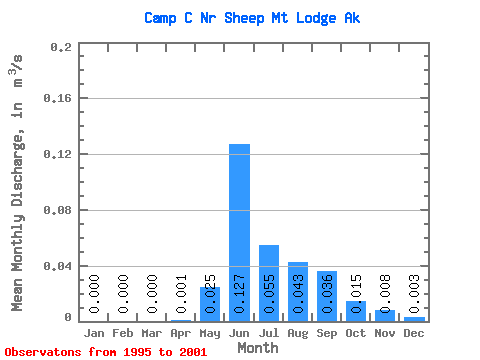
| Statistic | Jan | Feb | Mar | Apr | May | Jun | Jul | Aug | Sep | Oct | Nov | Dec | Annual |
|---|---|---|---|---|---|---|---|---|---|---|---|---|---|
| Mean | 0.00 | 0.00 | 0.00 | 0.00 | 0.03 | 0.13 | 0.06 | 0.04 | 0.04 | 0.01 | 0.01 | 0.00 | 0.02 |
| Standard Deviation | 0.00 | 0.00 | 0.00 | 0.00 | 0.01 | 0.09 | 0.03 | 0.03 | 0.02 | 0.01 | 0.01 | 0.00 | 0.01 |
| Min | 0.00 | 0.00 | 0.00 | 0.00 | 0.01 | 0.02 | 0.01 | 0.01 | 0.01 | 0.01 | 0.00 | 0.00 | 0.01 |
| Max | 0.00 | 0.00 | 0.00 | 0.00 | 0.04 | 0.24 | 0.08 | 0.10 | 0.07 | 0.03 | 0.02 | 0.01 | 0.04 |
| Coefficient of Variation | 1.72 | 1.29 | 0.58 | 0.74 | 0.47 | 0.75 | 0.68 | 0.60 | 1.01 | 1.57 | 0.57 |
 Return to R-Arctic Net Home Page