|
|
|||||||||||||||||
| Point ID: 95 | Downloads | Plots | Site Data | Code: 05AD017 |
|
|
|||||||||||||||||
| Download | |
|---|---|
| Site Descriptor Information | Site Time Series Data |
| Link to all available data | |
| View: | Time Series | All |
| Units: | mm |
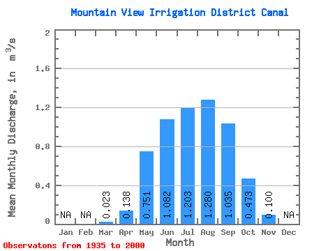
| Statistic | Jan | Feb | Mar | Apr | May | Jun | Jul | Aug | Sep | Oct | Nov | Dec | Annual |
|---|---|---|---|---|---|---|---|---|---|---|---|---|---|
| Mean | 0.02 | 0.14 | 0.75 | 1.08 | 1.20 | 1.28 | 1.03 | 0.47 | 0.10 | ||||
| Standard Deviation | 0.05 | 0.22 | 0.80 | 0.88 | 0.85 | 0.88 | 0.68 | 0.44 | 0.23 | ||||
| Min | 0.00 | 0.00 | 0.00 | 0.00 | 0.00 | 0.00 | 0.00 | 0.00 | 0.00 | ||||
| Max | 0.18 | 0.94 | 3.19 | 3.32 | 3.18 | 3.36 | 2.59 | 2.10 | 1.49 | ||||
| Coefficient of Variation | 2.13 | 1.62 | 1.06 | 0.81 | 0.70 | 0.69 | 0.65 | 0.93 | 2.29 |
 Return to R-Arctic Net Home Page