|
|
|||||||||||||||||
| Point ID: 9495 | Downloads | Plots | Site Data | Code: 15296550 |
|
|
|||||||||||||||||
| Download | |
|---|---|
| Site Descriptor Information | Site Time Series Data |
| Link to all available data | |
| View: | Time Series | All |
| Units: | mm |
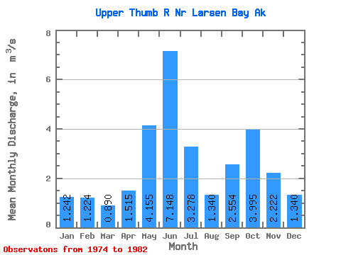
| Statistic | Jan | Feb | Mar | Apr | May | Jun | Jul | Aug | Sep | Oct | Nov | Dec | Annual |
|---|---|---|---|---|---|---|---|---|---|---|---|---|---|
| Mean | 1.24 | 1.22 | 0.89 | 1.52 | 4.16 | 7.15 | 3.28 | 1.34 | 2.55 | 4.00 | 2.22 | 1.34 | 2.63 |
| Standard Deviation | 0.91 | 0.81 | 0.45 | 0.99 | 1.01 | 2.49 | 1.46 | 0.64 | 1.16 | 1.30 | 1.45 | 0.92 | 0.38 |
| Min | 0.44 | 0.35 | 0.27 | 0.52 | 3.10 | 4.62 | 0.76 | 0.89 | 1.18 | 2.23 | 0.77 | 0.42 | 2.19 |
| Max | 3.04 | 2.52 | 1.54 | 3.62 | 5.79 | 12.14 | 5.62 | 2.78 | 4.37 | 6.58 | 5.34 | 2.73 | 3.12 |
| Coefficient of Variation | 0.73 | 0.66 | 0.51 | 0.65 | 0.24 | 0.35 | 0.44 | 0.48 | 0.45 | 0.32 | 0.65 | 0.68 | 0.15 |
 Return to R-Arctic Net Home Page