|
|
|||||||||||||||||
| Point ID: 9485 | Downloads | Plots | Site Data | Code: 15294700 |
|
|
|||||||||||||||||
| Download | |
|---|---|
| Site Descriptor Information | Site Time Series Data |
| Link to all available data | |
| View: | Time Series | All |
| Units: | mm |
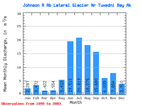
| Statistic | Jan | Feb | Mar | Apr | May | Jun | Jul | Aug | Sep | Oct | Nov | Dec | Annual |
|---|---|---|---|---|---|---|---|---|---|---|---|---|---|
| Mean | 2.29 | 3.47 | 1.42 | 1.55 | 5.41 | 19.52 | 20.82 | 18.07 | 15.68 | 6.04 | 7.85 | 3.91 | |
| Standard Deviation | 2.79 | 3.50 | 5.21 | 4.37 | 9.81 | 4.82 | 6.37 | ||||||
| Min | 2.29 | 3.47 | 1.42 | 1.55 | 2.17 | 15.81 | 14.00 | 11.39 | 5.52 | 1.77 | 3.35 | 3.91 | |
| Max | 2.29 | 3.47 | 1.42 | 1.55 | 9.82 | 26.62 | 30.42 | 24.20 | 38.20 | 15.39 | 12.36 | 3.91 | |
| Coefficient of Variation | 0.51 | 0.18 | 0.25 | 0.24 | 0.63 | 0.80 | 0.81 |
 Return to R-Arctic Net Home Page