|
|
|||||||||||||||||
| Point ID: 9471 | Downloads | Plots | Site Data | Code: 15246000 |
|
|
|||||||||||||||||
| Download | |
|---|---|
| Site Descriptor Information | Site Time Series Data |
| Link to all available data | |
| View: | Time Series | All |
| Units: | mm |
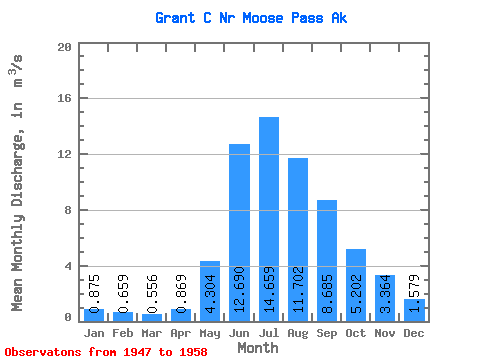
| Statistic | Jan | Feb | Mar | Apr | May | Jun | Jul | Aug | Sep | Oct | Nov | Dec | Annual |
|---|---|---|---|---|---|---|---|---|---|---|---|---|---|
| Mean | 0.88 | 0.66 | 0.56 | 0.87 | 4.30 | 12.69 | 14.66 | 11.70 | 8.69 | 5.20 | 3.36 | 1.58 | 5.40 |
| Standard Deviation | 0.38 | 0.26 | 0.17 | 0.48 | 1.86 | 5.07 | 2.85 | 1.53 | 3.77 | 2.57 | 2.21 | 1.00 | 0.98 |
| Min | 0.42 | 0.35 | 0.39 | 0.41 | 1.87 | 7.61 | 10.15 | 9.21 | 4.39 | 1.83 | 0.94 | 0.59 | 4.19 |
| Max | 1.63 | 1.26 | 0.86 | 1.86 | 7.96 | 26.29 | 20.14 | 14.53 | 16.00 | 9.54 | 7.44 | 3.52 | 7.76 |
| Coefficient of Variation | 0.43 | 0.40 | 0.30 | 0.55 | 0.43 | 0.40 | 0.19 | 0.13 | 0.43 | 0.49 | 0.66 | 0.64 | 0.18 |
 Return to R-Arctic Net Home Page