|
|
|||||||||||||||||
| Point ID: 9468 | Downloads | Plots | Site Data | Code: 15243500 |
|
|
|||||||||||||||||
| Download | |
|---|---|
| Site Descriptor Information | Site Time Series Data |
| Link to all available data | |
| View: | Time Series | All |
| Units: | mm |
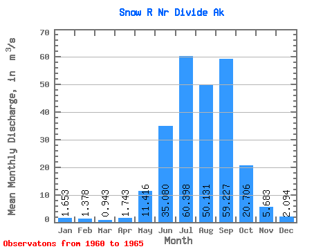
| Statistic | Jan | Feb | Mar | Apr | May | Jun | Jul | Aug | Sep | Oct | Nov | Dec | Annual |
|---|---|---|---|---|---|---|---|---|---|---|---|---|---|
| Mean | 1.65 | 1.38 | 0.94 | 1.74 | 11.42 | 35.08 | 60.40 | 50.13 | 59.23 | 20.71 | 5.68 | 2.09 | 20.62 |
| Standard Deviation | 1.10 | 0.86 | 0.47 | 0.99 | 5.66 | 8.03 | 5.94 | 4.39 | 33.31 | 13.94 | 3.20 | 0.71 | 4.65 |
| Min | 0.99 | 0.68 | 0.57 | 0.94 | 4.45 | 22.07 | 54.20 | 46.13 | 20.93 | 4.66 | 2.67 | 1.28 | 16.11 |
| Max | 3.60 | 2.80 | 1.71 | 3.38 | 20.19 | 44.20 | 68.85 | 55.90 | 97.39 | 35.74 | 10.11 | 3.12 | 25.59 |
| Coefficient of Variation | 0.67 | 0.63 | 0.50 | 0.57 | 0.50 | 0.23 | 0.10 | 0.09 | 0.56 | 0.67 | 0.56 | 0.34 | 0.23 |
 Return to R-Arctic Net Home Page