|
|
|||||||||||||||||
| Point ID: 9462 | Downloads | Plots | Site Data | Code: 15239500 |
|
|
|||||||||||||||||
| Download | |
|---|---|
| Site Descriptor Information | Site Time Series Data |
| Link to all available data | |
| View: | Time Series | All |
| Units: | mm |
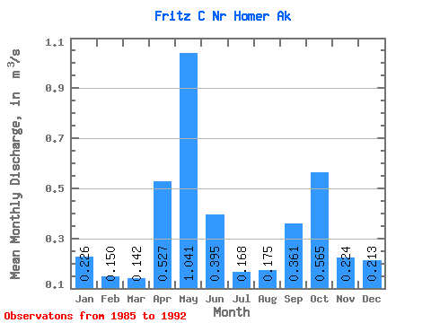
| Statistic | Jan | Feb | Mar | Apr | May | Jun | Jul | Aug | Sep | Oct | Nov | Dec | Annual |
|---|---|---|---|---|---|---|---|---|---|---|---|---|---|
| Mean | 0.23 | 0.15 | 0.14 | 0.53 | 1.04 | 0.40 | 0.17 | 0.17 | 0.36 | 0.56 | 0.22 | 0.21 | 0.35 |
| Standard Deviation | 0.14 | 0.06 | 0.06 | 0.15 | 0.51 | 0.22 | 0.07 | 0.06 | 0.16 | 0.28 | 0.13 | 0.15 | 0.10 |
| Min | 0.07 | 0.06 | 0.06 | 0.26 | 0.56 | 0.21 | 0.10 | 0.10 | 0.21 | 0.26 | 0.13 | 0.07 | 0.25 |
| Max | 0.47 | 0.23 | 0.21 | 0.73 | 1.74 | 0.81 | 0.26 | 0.27 | 0.61 | 0.97 | 0.49 | 0.52 | 0.47 |
| Coefficient of Variation | 0.64 | 0.37 | 0.43 | 0.29 | 0.49 | 0.56 | 0.39 | 0.35 | 0.44 | 0.50 | 0.60 | 0.69 | 0.27 |
 Return to R-Arctic Net Home Page