|
|
|||||||||||||||||
| Point ID: 9456 | Downloads | Plots | Site Data | Code: 15238990 |
|
|
|||||||||||||||||
| Download | |
|---|---|
| Site Descriptor Information | Site Time Series Data |
| Link to all available data | |
| View: | Time Series | All |
| Units: | mm |
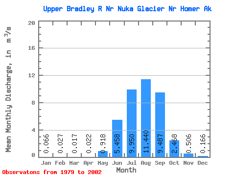
| Statistic | Jan | Feb | Mar | Apr | May | Jun | Jul | Aug | Sep | Oct | Nov | Dec | Annual |
|---|---|---|---|---|---|---|---|---|---|---|---|---|---|
| Mean | 0.07 | 0.03 | 0.02 | 0.02 | 0.92 | 5.46 | 9.95 | 11.44 | 9.49 | 2.47 | 0.51 | 0.17 | 3.34 |
| Standard Deviation | 0.11 | 0.04 | 0.04 | 0.04 | 0.96 | 2.06 | 3.99 | 4.12 | 5.58 | 2.01 | 0.52 | 0.33 | 1.13 |
| Min | 0.00 | 0.00 | 0.00 | 0.00 | 0.00 | 2.67 | 3.01 | 3.76 | 1.79 | 0.36 | 0.07 | 0.00 | 1.35 |
| Max | 0.43 | 0.14 | 0.18 | 0.13 | 3.54 | 10.29 | 21.62 | 16.90 | 24.11 | 7.89 | 2.14 | 1.55 | 5.08 |
| Coefficient of Variation | 1.68 | 1.64 | 2.45 | 1.77 | 1.04 | 0.38 | 0.40 | 0.36 | 0.59 | 0.81 | 1.04 | 1.99 | 0.34 |
 Return to R-Arctic Net Home Page