|
|
|||||||||||||||||
| Point ID: 9449 | Downloads | Plots | Site Data | Code: 15274600 |
|
|
|||||||||||||||||
| Download | |
|---|---|
| Site Descriptor Information | Site Time Series Data |
| Link to all available data | |
| View: | Time Series | All |
| Units: | mm |
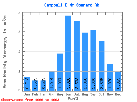
| Statistic | Jan | Feb | Mar | Apr | May | Jun | Jul | Aug | Sep | Oct | Nov | Dec | Annual |
|---|---|---|---|---|---|---|---|---|---|---|---|---|---|
| Mean | 0.71 | 0.54 | 0.54 | 1.01 | 1.90 | 3.83 | 3.53 | 2.97 | 3.09 | 2.54 | 1.37 | 0.97 | 1.91 |
| Standard Deviation | 0.26 | 0.23 | 0.26 | 0.51 | 0.83 | 0.97 | 0.93 | 1.31 | 1.22 | 0.88 | 0.51 | 0.32 | 0.41 |
| Min | 0.23 | 0.19 | 0.17 | 0.23 | 0.76 | 2.43 | 1.98 | 1.45 | 1.00 | 1.15 | 0.65 | 0.48 | 1.17 |
| Max | 1.38 | 0.99 | 1.17 | 2.57 | 4.87 | 6.21 | 6.31 | 6.20 | 6.19 | 4.54 | 2.43 | 1.92 | 2.83 |
| Coefficient of Variation | 0.36 | 0.42 | 0.48 | 0.50 | 0.44 | 0.25 | 0.26 | 0.44 | 0.39 | 0.35 | 0.37 | 0.33 | 0.21 |
 Return to R-Arctic Net Home Page