|
|
|||||||||||||||||
| Point ID: 9446 | Downloads | Plots | Site Data | Code: 15274000 |
|
|
|||||||||||||||||
| Download | |
|---|---|
| Site Descriptor Information | Site Time Series Data |
| Link to all available data | |
| View: | Time Series | All |
| Units: | mm |
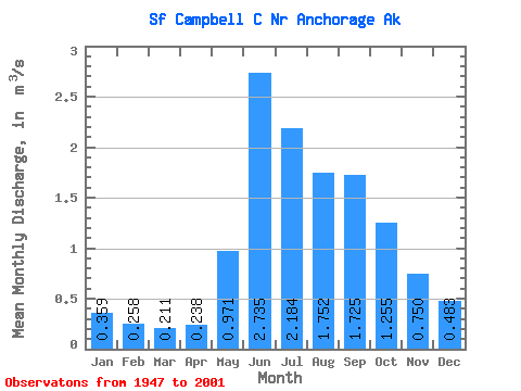
| Statistic | Jan | Feb | Mar | Apr | May | Jun | Jul | Aug | Sep | Oct | Nov | Dec | Annual |
|---|---|---|---|---|---|---|---|---|---|---|---|---|---|
| Mean | 0.36 | 0.26 | 0.21 | 0.24 | 0.97 | 2.73 | 2.18 | 1.75 | 1.73 | 1.25 | 0.75 | 0.48 | 1.08 |
| Standard Deviation | 0.15 | 0.09 | 0.07 | 0.10 | 0.38 | 0.81 | 0.76 | 0.50 | 0.69 | 0.47 | 0.26 | 0.13 | 0.21 |
| Min | 0.17 | 0.11 | 0.10 | 0.10 | 0.30 | 1.39 | 1.07 | 0.90 | 0.60 | 0.55 | 0.33 | 0.30 | 0.67 |
| Max | 0.94 | 0.48 | 0.34 | 0.58 | 1.78 | 4.70 | 4.27 | 2.67 | 3.47 | 2.37 | 1.59 | 0.88 | 1.48 |
| Coefficient of Variation | 0.41 | 0.33 | 0.31 | 0.41 | 0.39 | 0.29 | 0.35 | 0.28 | 0.40 | 0.37 | 0.34 | 0.27 | 0.20 |
 Return to R-Arctic Net Home Page