|
|
|||||||||||||||||
| Point ID: 9404 | Downloads | Plots | Site Data | Code: 644322147192900 |
|
|
|||||||||||||||||
| Download | |
|---|---|
| Site Descriptor Information | Site Time Series Data |
| Link to all available data | |
| View: | Time Series | All |
| Units: | mm |
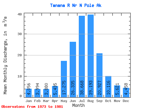
| Statistic | Jan | Feb | Mar | Apr | May | Jun | Jul | Aug | Sep | Oct | Nov | Dec | Annual |
|---|---|---|---|---|---|---|---|---|---|---|---|---|---|
| Mean | 4.06 | 3.99 | 3.88 | 5.43 | 17.27 | 26.34 | 38.67 | 39.19 | 20.93 | 10.12 | 5.62 | 4.46 | 15.08 |
| Standard Deviation | 0.64 | 0.75 | 0.69 | 1.17 | 3.69 | 4.38 | 5.05 | 5.02 | 4.20 | 2.46 | 1.14 | 0.63 | 1.88 |
| Min | 3.22 | 2.57 | 2.49 | 3.39 | 14.52 | 20.15 | 31.85 | 34.11 | 13.59 | 7.22 | 4.01 | 3.60 | 13.02 |
| Max | 4.81 | 4.73 | 4.54 | 6.86 | 23.77 | 33.62 | 46.05 | 49.43 | 28.01 | 13.97 | 7.72 | 5.53 | 17.74 |
| Coefficient of Variation | 0.16 | 0.19 | 0.18 | 0.21 | 0.21 | 0.17 | 0.13 | 0.13 | 0.20 | 0.24 | 0.20 | 0.14 | 0.12 |
 Return to R-Arctic Net Home Page