|
|
|||||||||||||||||
| Point ID: 9365 | Downloads | Plots | Site Data | Code: 15297625 |
|
|
|||||||||||||||||
| Download | |
|---|---|
| Site Descriptor Information | Site Time Series Data |
| Link to all available data | |
| View: | Time Series | All |
| Units: | mm |
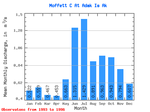
| Statistic | Jan | Feb | Mar | Apr | May | Jun | Jul | Aug | Sep | Oct | Nov | Dec | Annual |
|---|---|---|---|---|---|---|---|---|---|---|---|---|---|
| Mean | 0.52 | 0.56 | 0.47 | 0.45 | 0.66 | 1.31 | 1.43 | 0.89 | 0.96 | 0.94 | 0.79 | 0.61 | 0.79 |
| Standard Deviation | 0.03 | 0.12 | 0.10 | 0.05 | 0.05 | 0.51 | 0.23 | 0.13 | 0.15 | 0.18 | 0.20 | 0.12 | 0.11 |
| Min | 0.50 | 0.44 | 0.37 | 0.40 | 0.63 | 0.96 | 1.27 | 0.80 | 0.86 | 0.76 | 0.59 | 0.51 | 0.71 |
| Max | 0.55 | 0.67 | 0.58 | 0.50 | 0.70 | 1.67 | 1.59 | 0.98 | 1.07 | 1.12 | 1.00 | 0.74 | 0.87 |
| Coefficient of Variation | 0.05 | 0.21 | 0.22 | 0.12 | 0.08 | 0.39 | 0.16 | 0.14 | 0.15 | 0.19 | 0.26 | 0.20 | 0.14 |
 Return to R-Arctic Net Home Page