|
|
|||||||||||||||||
| Point ID: 9355 | Downloads | Plots | Site Data | Code: 15476300 |
|
|
|||||||||||||||||
| Download | |
|---|---|
| Site Descriptor Information | Site Time Series Data |
| Link to all available data | |
| View: | Time Series | All |
| Units: | mm |
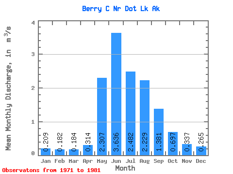
| Statistic | Jan | Feb | Mar | Apr | May | Jun | Jul | Aug | Sep | Oct | Nov | Dec | Annual |
|---|---|---|---|---|---|---|---|---|---|---|---|---|---|
| Mean | 0.21 | 0.18 | 0.18 | 0.31 | 2.31 | 3.64 | 2.48 | 2.23 | 1.38 | 0.70 | 0.34 | 0.27 | 1.21 |
| Standard Deviation | 0.10 | 0.10 | 0.10 | 0.18 | 1.01 | 1.61 | 0.68 | 0.73 | 0.39 | 0.26 | 0.12 | 0.11 | 0.29 |
| Min | 0.02 | 0.02 | 0.02 | 0.06 | 0.91 | 1.43 | 1.30 | 1.33 | 0.97 | 0.39 | 0.13 | 0.04 | 0.83 |
| Max | 0.34 | 0.31 | 0.31 | 0.56 | 3.96 | 6.16 | 3.99 | 4.12 | 2.30 | 1.16 | 0.48 | 0.41 | 1.88 |
| Coefficient of Variation | 0.49 | 0.54 | 0.55 | 0.56 | 0.44 | 0.44 | 0.27 | 0.33 | 0.28 | 0.37 | 0.35 | 0.42 | 0.24 |
 Return to R-Arctic Net Home Page