|
|
|||||||||||||||||
| Point ID: 9344 | Downloads | Plots | Site Data | Code: 15302000 |
|
|
|||||||||||||||||
| Download | |
|---|---|
| Site Descriptor Information | Site Time Series Data |
| Link to all available data | |
| View: | Time Series | All |
| Units: | mm |
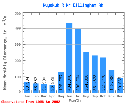
| Statistic | Jan | Feb | Mar | Apr | May | Jun | Jul | Aug | Sep | Oct | Nov | Dec | Annual |
|---|---|---|---|---|---|---|---|---|---|---|---|---|---|
| Mean | 69.50 | 58.85 | 51.98 | 50.53 | 128.80 | 434.91 | 396.73 | 254.83 | 231.62 | 219.78 | 142.00 | 90.87 | 178.91 |
| Standard Deviation | 15.98 | 13.30 | 11.35 | 11.98 | 59.06 | 90.98 | 117.50 | 92.95 | 74.74 | 74.55 | 46.23 | 25.79 | 29.55 |
| Min | 39.55 | 35.45 | 28.04 | 22.65 | 48.69 | 293.38 | 192.37 | 109.17 | 116.06 | 108.07 | 72.77 | 52.34 | 120.11 |
| Max | 113.42 | 90.61 | 86.11 | 76.23 | 320.62 | 659.59 | 742.45 | 684.99 | 483.27 | 378.02 | 260.30 | 184.06 | 244.23 |
| Coefficient of Variation | 0.23 | 0.23 | 0.22 | 0.24 | 0.46 | 0.21 | 0.30 | 0.36 | 0.32 | 0.34 | 0.33 | 0.28 | 0.17 |
 Return to R-Arctic Net Home Page