|
|
|||||||||||||||||
| Point ID: 9334 | Downloads | Plots | Site Data | Code: 15304200 |
|
|
|||||||||||||||||
| Download | |
|---|---|
| Site Descriptor Information | Site Time Series Data |
| Link to all available data | |
| View: | Time Series | All |
| Units: | mm |
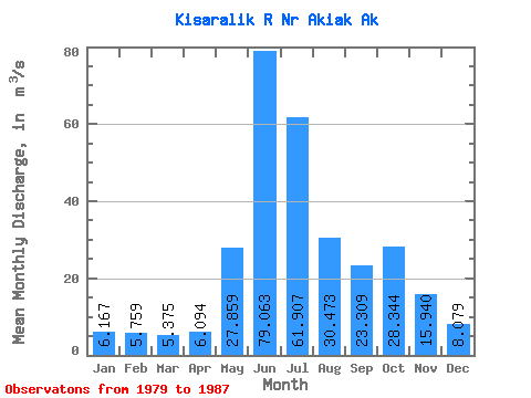
| Statistic | Jan | Feb | Mar | Apr | May | Jun | Jul | Aug | Sep | Oct | Nov | Dec | Annual |
|---|---|---|---|---|---|---|---|---|---|---|---|---|---|
| Mean | 6.17 | 5.76 | 5.38 | 6.09 | 27.86 | 79.06 | 61.91 | 30.47 | 23.31 | 28.34 | 15.94 | 8.08 | 23.49 |
| Standard Deviation | 1.75 | 1.35 | 1.07 | 2.12 | 13.92 | 17.86 | 17.42 | 9.92 | 7.64 | 20.09 | 17.52 | 5.33 | 5.74 |
| Min | 3.61 | 3.54 | 3.42 | 3.54 | 12.50 | 43.83 | 38.35 | 15.75 | 12.33 | 13.11 | 4.62 | 3.68 | 14.47 |
| Max | 8.54 | 7.76 | 6.60 | 9.39 | 54.31 | 97.19 | 90.77 | 42.69 | 34.73 | 73.81 | 57.20 | 20.20 | 32.22 |
| Coefficient of Variation | 0.28 | 0.23 | 0.20 | 0.35 | 0.50 | 0.23 | 0.28 | 0.33 | 0.33 | 0.71 | 1.10 | 0.66 | 0.24 |
 Return to R-Arctic Net Home Page