|
|
|||||||||||||||||
| Point ID: 9329 | Downloads | Plots | Site Data | Code: 15067900 |
|
|
|||||||||||||||||
| Download | |
|---|---|
| Site Descriptor Information | Site Time Series Data |
| Link to all available data | |
| View: | Time Series | All |
| Units: | mm |
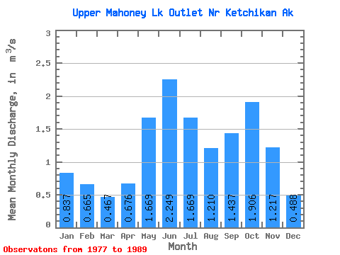
| Statistic | Jan | Feb | Mar | Apr | May | Jun | Jul | Aug | Sep | Oct | Nov | Dec | Annual |
|---|---|---|---|---|---|---|---|---|---|---|---|---|---|
| Mean | 0.84 | 0.67 | 0.47 | 0.68 | 1.67 | 2.25 | 1.67 | 1.21 | 1.44 | 1.91 | 1.22 | 0.49 | 1.24 |
| Standard Deviation | 0.73 | 0.42 | 0.38 | 0.23 | 0.43 | 0.66 | 0.57 | 0.53 | 0.64 | 0.74 | 0.83 | 0.34 | 0.23 |
| Min | 0.07 | 0.06 | 0.07 | 0.33 | 0.82 | 1.00 | 0.69 | 0.42 | 0.79 | 0.89 | 0.23 | 0.05 | 0.89 |
| Max | 2.61 | 1.29 | 1.54 | 1.07 | 2.34 | 3.48 | 2.42 | 2.15 | 2.79 | 3.32 | 2.83 | 1.04 | 1.60 |
| Coefficient of Variation | 0.87 | 0.63 | 0.81 | 0.35 | 0.26 | 0.29 | 0.34 | 0.44 | 0.45 | 0.39 | 0.68 | 0.71 | 0.18 |
 Return to R-Arctic Net Home Page