|
|
|||||||||||||||||
| Point ID: 9324 | Downloads | Plots | Site Data | Code: 15059500 |
|
|
|||||||||||||||||
| Download | |
|---|---|
| Site Descriptor Information | Site Time Series Data |
| Link to all available data | |
| View: | Time Series | All |
| Units: | mm |
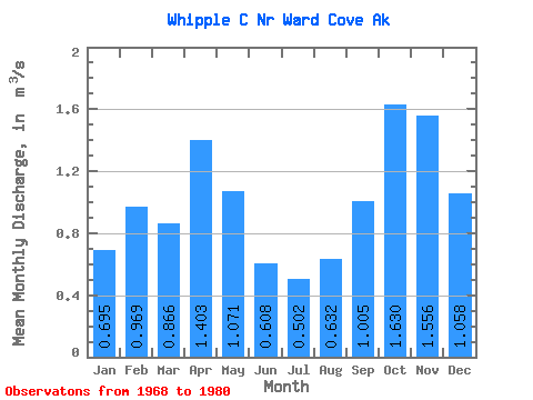
| Statistic | Jan | Feb | Mar | Apr | May | Jun | Jul | Aug | Sep | Oct | Nov | Dec | Annual |
|---|---|---|---|---|---|---|---|---|---|---|---|---|---|
| Mean | 0.69 | 0.97 | 0.87 | 1.40 | 1.07 | 0.61 | 0.50 | 0.63 | 1.00 | 1.63 | 1.56 | 1.06 | 0.98 |
| Standard Deviation | 0.38 | 0.56 | 0.34 | 0.98 | 0.33 | 0.24 | 0.23 | 0.42 | 0.38 | 0.76 | 0.96 | 0.58 | 0.18 |
| Min | 0.11 | 0.22 | 0.36 | 0.46 | 0.40 | 0.15 | 0.18 | 0.11 | 0.28 | 0.84 | 0.22 | 0.44 | 0.74 |
| Max | 1.26 | 1.80 | 1.65 | 4.04 | 1.45 | 0.93 | 0.90 | 1.47 | 1.59 | 3.15 | 3.94 | 2.13 | 1.37 |
| Coefficient of Variation | 0.55 | 0.57 | 0.39 | 0.70 | 0.31 | 0.39 | 0.46 | 0.67 | 0.38 | 0.47 | 0.62 | 0.55 | 0.19 |
 Return to R-Arctic Net Home Page