|
|
|||||||||||||||||
| Point ID: 9298 | Downloads | Plots | Site Data | Code: 15081995 |
|
|
|||||||||||||||||
| Download | |
|---|---|
| Site Descriptor Information | Site Time Series Data |
| Link to all available data | |
| View: | Time Series | All |
| Units: | mm |
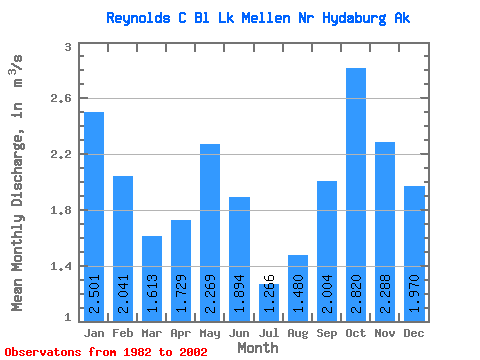
| Statistic | Jan | Feb | Mar | Apr | May | Jun | Jul | Aug | Sep | Oct | Nov | Dec | Annual |
|---|---|---|---|---|---|---|---|---|---|---|---|---|---|
| Mean | 2.50 | 2.04 | 1.61 | 1.73 | 2.27 | 1.89 | 1.27 | 1.48 | 2.00 | 2.82 | 2.29 | 1.97 | 2.02 |
| Standard Deviation | 0.63 | 0.66 | 0.65 | 0.60 | 0.75 | 0.72 | 0.42 | 0.59 | 0.82 | 0.89 | 0.81 | 0.94 | 0.32 |
| Min | 1.74 | 1.35 | 0.71 | 0.68 | 1.15 | 0.65 | 0.57 | 0.55 | 0.91 | 2.15 | 1.54 | 0.59 | 1.63 |
| Max | 3.65 | 3.02 | 2.77 | 2.57 | 3.64 | 2.93 | 1.80 | 2.23 | 3.50 | 4.88 | 4.01 | 3.71 | 2.46 |
| Coefficient of Variation | 0.25 | 0.32 | 0.40 | 0.35 | 0.33 | 0.38 | 0.33 | 0.40 | 0.41 | 0.31 | 0.35 | 0.48 | 0.16 |
 Return to R-Arctic Net Home Page