|
|
|||||||||||||||||
| Point ID: 9295 | Downloads | Plots | Site Data | Code: 15054200 |
|
|
|||||||||||||||||
| Download | |
|---|---|
| Site Descriptor Information | Site Time Series Data |
| Link to all available data | |
| View: | Time Series | All |
| Units: | mm |
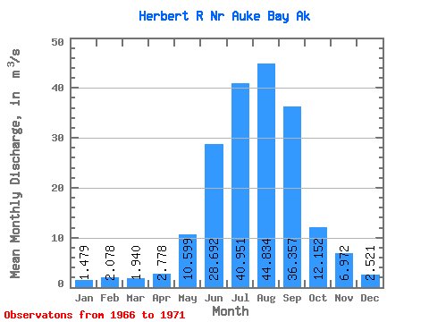
| Statistic | Jan | Feb | Mar | Apr | May | Jun | Jul | Aug | Sep | Oct | Nov | Dec | Annual |
|---|---|---|---|---|---|---|---|---|---|---|---|---|---|
| Mean | 1.48 | 2.08 | 1.94 | 2.78 | 10.60 | 28.69 | 40.95 | 44.83 | 36.36 | 12.15 | 6.97 | 2.52 | 16.05 |
| Standard Deviation | 0.84 | 1.41 | 1.71 | 0.46 | 2.16 | 7.03 | 4.89 | 9.90 | 9.06 | 3.55 | 3.21 | 2.44 | 1.09 |
| Min | 0.54 | 0.48 | 0.54 | 2.14 | 8.05 | 22.80 | 35.55 | 33.74 | 25.69 | 8.78 | 3.90 | 1.07 | 14.93 |
| Max | 2.81 | 3.84 | 4.29 | 3.23 | 12.96 | 38.45 | 46.85 | 54.97 | 50.29 | 17.65 | 11.71 | 6.85 | 17.48 |
| Coefficient of Variation | 0.57 | 0.68 | 0.88 | 0.17 | 0.20 | 0.24 | 0.12 | 0.22 | 0.25 | 0.29 | 0.46 | 0.97 | 0.07 |
 Return to R-Arctic Net Home Page