|
|
|||||||||||||||||
| Point ID: 9286 | Downloads | Plots | Site Data | Code: 15078000 |
|
|
|||||||||||||||||
| Download | |
|---|---|
| Site Descriptor Information | Site Time Series Data |
| Link to all available data | |
| View: | Time Series | All |
| Units: | mm |
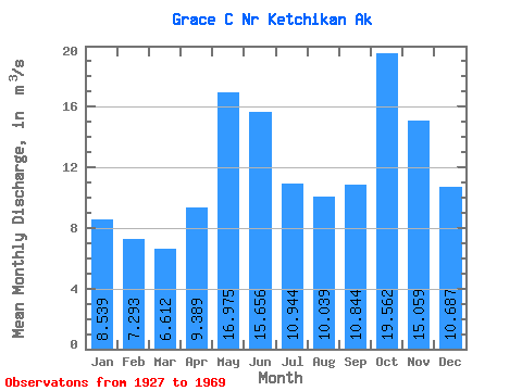
| Statistic | Jan | Feb | Mar | Apr | May | Jun | Jul | Aug | Sep | Oct | Nov | Dec | Annual |
|---|---|---|---|---|---|---|---|---|---|---|---|---|---|
| Mean | 8.54 | 7.29 | 6.61 | 9.39 | 16.98 | 15.66 | 10.94 | 10.04 | 10.84 | 19.56 | 15.06 | 10.69 | 11.99 |
| Standard Deviation | 4.61 | 3.96 | 3.33 | 3.04 | 3.06 | 3.89 | 4.28 | 4.44 | 6.44 | 4.57 | 6.83 | 7.69 | 1.21 |
| Min | 1.40 | 0.91 | 1.84 | 3.48 | 11.10 | 8.79 | 7.22 | 1.81 | 2.08 | 11.84 | 4.24 | 4.02 | 8.98 |
| Max | 16.54 | 13.41 | 13.17 | 16.02 | 20.66 | 24.82 | 21.83 | 17.32 | 21.57 | 26.30 | 25.57 | 29.51 | 14.26 |
| Coefficient of Variation | 0.54 | 0.54 | 0.50 | 0.32 | 0.18 | 0.25 | 0.39 | 0.44 | 0.59 | 0.23 | 0.45 | 0.72 | 0.10 |
 Return to R-Arctic Net Home Page