|
|
|||||||||||||||||
| Point ID: 9282 | Downloads | Plots | Site Data | Code: 15028300 |
|
|
|||||||||||||||||
| Download | |
|---|---|
| Site Descriptor Information | Site Time Series Data |
| Link to all available data | |
| View: | Time Series | All |
| Units: | mm |
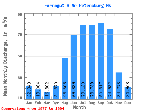
| Statistic | Jan | Feb | Mar | Apr | May | Jun | Jul | Aug | Sep | Oct | Nov | Dec | Annual |
|---|---|---|---|---|---|---|---|---|---|---|---|---|---|
| Mean | 22.35 | 19.08 | 16.80 | 21.87 | 48.61 | 69.84 | 79.12 | 78.74 | 80.82 | 74.92 | 34.77 | 20.91 | 47.45 |
| Standard Deviation | 14.58 | 12.41 | 9.53 | 5.20 | 10.88 | 8.93 | 11.67 | 12.69 | 27.79 | 25.34 | 17.68 | 12.69 | 5.47 |
| Min | 4.26 | 3.57 | 4.64 | 10.91 | 30.21 | 52.56 | 60.75 | 57.82 | 41.04 | 42.62 | 8.67 | 3.87 | 36.18 |
| Max | 52.19 | 41.67 | 35.32 | 29.72 | 63.31 | 80.61 | 108.24 | 97.25 | 135.30 | 126.96 | 61.16 | 50.96 | 59.69 |
| Coefficient of Variation | 0.65 | 0.65 | 0.57 | 0.24 | 0.22 | 0.13 | 0.15 | 0.16 | 0.34 | 0.34 | 0.51 | 0.61 | 0.12 |
 Return to R-Arctic Net Home Page