|
|
|||||||||||||||||
| Point ID: 9272 | Downloads | Plots | Site Data | Code: 15019990 |
|
|
|||||||||||||||||
| Download | |
|---|---|
| Site Descriptor Information | Site Time Series Data |
| Link to all available data | |
| View: | Time Series | All |
| Units: | mm |
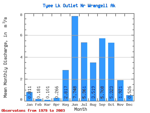
| Statistic | Jan | Feb | Mar | Apr | May | Jun | Jul | Aug | Sep | Oct | Nov | Dec | Annual |
|---|---|---|---|---|---|---|---|---|---|---|---|---|---|
| Mean | 0.81 | 0.18 | 0.10 | 0.27 | 2.82 | 7.75 | 5.36 | 3.52 | 5.71 | 5.32 | 1.92 | 0.53 | 2.66 |
| Standard Deviation | 2.24 | 0.53 | 0.32 | 0.53 | 2.71 | 1.88 | 2.39 | 1.98 | 2.90 | 3.15 | 1.71 | 0.62 | 0.94 |
| Min | 0.00 | 0.00 | 0.00 | 0.00 | 0.00 | 5.00 | 1.56 | 0.54 | 1.17 | 1.87 | 0.14 | 0.00 | 1.72 |
| Max | 8.11 | 1.91 | 1.17 | 1.78 | 7.79 | 11.10 | 8.64 | 6.13 | 12.17 | 14.36 | 6.33 | 1.82 | 4.92 |
| Coefficient of Variation | 2.77 | 2.92 | 3.18 | 2.00 | 0.96 | 0.24 | 0.45 | 0.56 | 0.51 | 0.59 | 0.89 | 1.18 | 0.35 |
 Return to R-Arctic Net Home Page