|
|
|||||||||||||||||
| Point ID: 9269 | Downloads | Plots | Site Data | Code: 15015600 |
|
|
|||||||||||||||||
| Download | |
|---|---|
| Site Descriptor Information | Site Time Series Data |
| Link to all available data | |
| View: | Time Series | All |
| Units: | mm |
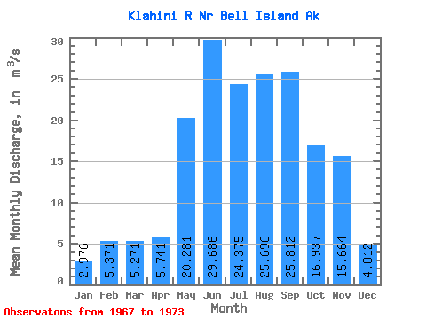
| Statistic | Jan | Feb | Mar | Apr | May | Jun | Jul | Aug | Sep | Oct | Nov | Dec | Annual |
|---|---|---|---|---|---|---|---|---|---|---|---|---|---|
| Mean | 2.98 | 5.37 | 5.27 | 5.74 | 20.28 | 29.69 | 24.38 | 25.70 | 25.81 | 16.94 | 15.66 | 4.81 | 15.14 |
| Standard Deviation | 2.01 | 4.79 | 3.31 | 1.59 | 6.16 | 7.43 | 4.54 | 7.58 | 6.80 | 5.43 | 12.78 | 3.45 | 1.96 |
| Min | 1.11 | 0.85 | 1.22 | 3.25 | 16.13 | 17.80 | 17.17 | 14.36 | 15.20 | 8.32 | 8.15 | 2.54 | 12.37 |
| Max | 6.68 | 12.06 | 9.29 | 7.76 | 32.42 | 36.21 | 32.40 | 35.65 | 33.99 | 22.31 | 41.29 | 11.56 | 17.86 |
| Coefficient of Variation | 0.67 | 0.89 | 0.63 | 0.28 | 0.30 | 0.25 | 0.19 | 0.29 | 0.26 | 0.32 | 0.82 | 0.72 | 0.13 |
 Return to R-Arctic Net Home Page