|
|
|||||||||||||||||
| Point ID: 9267 | Downloads | Plots | Site Data | Code: 15012000 |
|
|
|||||||||||||||||
| Download | |
|---|---|
| Site Descriptor Information | Site Time Series Data |
| Link to all available data | |
| View: | Time Series | All |
| Units: | mm |
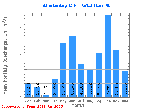
| Statistic | Jan | Feb | Mar | Apr | May | Jun | Jul | Aug | Sep | Oct | Nov | Dec | Annual |
|---|---|---|---|---|---|---|---|---|---|---|---|---|---|
| Mean | 2.93 | 2.75 | 2.17 | 3.30 | 5.85 | 6.35 | 4.38 | 3.92 | 5.15 | 7.86 | 5.37 | 3.83 | 4.49 |
| Standard Deviation | 2.29 | 2.00 | 1.20 | 1.31 | 1.33 | 1.32 | 1.39 | 1.83 | 1.94 | 2.57 | 2.06 | 2.15 | 0.61 |
| Min | 0.28 | 0.17 | 0.67 | 1.03 | 3.17 | 2.72 | 1.21 | 0.78 | 1.65 | 2.76 | 1.35 | 0.73 | 3.36 |
| Max | 11.38 | 9.26 | 4.25 | 6.51 | 9.29 | 9.60 | 6.38 | 7.58 | 9.97 | 14.28 | 10.91 | 9.66 | 5.60 |
| Coefficient of Variation | 0.78 | 0.72 | 0.55 | 0.40 | 0.23 | 0.21 | 0.32 | 0.47 | 0.38 | 0.33 | 0.38 | 0.56 | 0.14 |
 Return to R-Arctic Net Home Page