|
|
|||||||||||||||||
| Point ID: 9264 | Downloads | Plots | Site Data | Code: 15011870 |
|
|
|||||||||||||||||
| Download | |
|---|---|
| Site Descriptor Information | Site Time Series Data |
| Link to all available data | |
| View: | Time Series | All |
| Units: | mm |
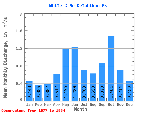
| Statistic | Jan | Feb | Mar | Apr | May | Jun | Jul | Aug | Sep | Oct | Nov | Dec | Annual |
|---|---|---|---|---|---|---|---|---|---|---|---|---|---|
| Mean | 0.45 | 0.36 | 0.39 | 0.62 | 1.19 | 1.23 | 0.70 | 0.63 | 0.87 | 1.48 | 0.71 | 0.45 | 0.76 |
| Standard Deviation | 0.32 | 0.19 | 0.17 | 0.28 | 0.24 | 0.54 | 0.23 | 0.32 | 0.52 | 0.41 | 0.39 | 0.44 | 0.09 |
| Min | 0.13 | 0.09 | 0.09 | 0.20 | 0.77 | 0.85 | 0.41 | 0.25 | 0.23 | 0.96 | 0.28 | 0.11 | 0.65 |
| Max | 1.06 | 0.57 | 0.58 | 0.97 | 1.53 | 2.37 | 1.16 | 1.07 | 1.99 | 2.05 | 1.31 | 1.20 | 0.89 |
| Coefficient of Variation | 0.71 | 0.54 | 0.44 | 0.46 | 0.20 | 0.44 | 0.33 | 0.51 | 0.59 | 0.28 | 0.54 | 0.98 | 0.12 |
 Return to R-Arctic Net Home Page