|
|
|||||||||||||||||
| Point ID: 9252 | Downloads | Plots | Site Data | Code: 15052009 |
|
|
|||||||||||||||||
| Download | |
|---|---|
| Site Descriptor Information | Site Time Series Data |
| Link to all available data | |
| View: | Time Series | All |
| Units: | mm |
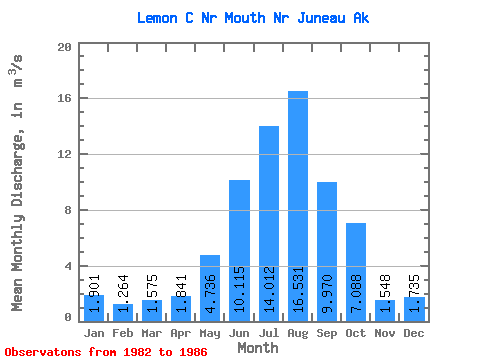
| Statistic | Jan | Feb | Mar | Apr | May | Jun | Jul | Aug | Sep | Oct | Nov | Dec | Annual |
|---|---|---|---|---|---|---|---|---|---|---|---|---|---|
| Mean | 1.90 | 1.26 | 1.57 | 1.84 | 4.74 | 10.12 | 14.01 | 16.53 | 9.97 | 7.09 | 1.55 | 1.73 | 5.91 |
| Standard Deviation | 1.07 | 0.44 | 1.02 | 0.71 | 1.40 | 1.47 | 3.46 | 3.18 | 2.53 | 2.32 | 0.10 | 1.80 | 0.51 |
| Min | 1.03 | 0.69 | 0.66 | 1.24 | 3.88 | 8.05 | 9.04 | 13.46 | 7.24 | 4.80 | 1.47 | 0.71 | 5.39 |
| Max | 3.37 | 1.66 | 2.83 | 2.84 | 6.81 | 11.42 | 16.99 | 20.45 | 12.55 | 10.29 | 1.69 | 4.43 | 6.42 |
| Coefficient of Variation | 0.56 | 0.35 | 0.65 | 0.39 | 0.30 | 0.14 | 0.25 | 0.19 | 0.25 | 0.33 | 0.06 | 1.04 | 0.09 |
 Return to R-Arctic Net Home Page