|
|
|||||||||||||||||
| Point ID: 9249 | Downloads | Plots | Site Data | Code: 15031000 |
|
|
|||||||||||||||||
| Download | |
|---|---|
| Site Descriptor Information | Site Time Series Data |
| Link to all available data | |
| View: | Time Series | All |
| Units: | mm |
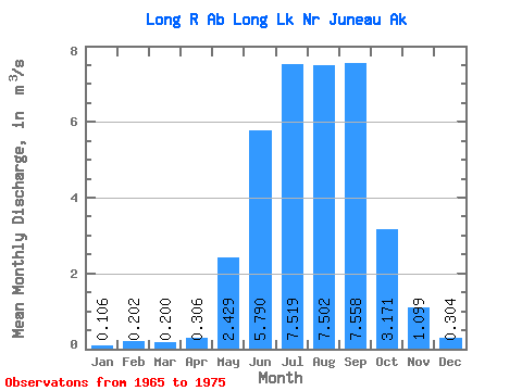
| Statistic | Jan | Feb | Mar | Apr | May | Jun | Jul | Aug | Sep | Oct | Nov | Dec | Annual |
|---|---|---|---|---|---|---|---|---|---|---|---|---|---|
| Mean | 0.11 | 0.20 | 0.20 | 0.31 | 2.43 | 5.79 | 7.52 | 7.50 | 7.56 | 3.17 | 1.10 | 0.30 | 2.97 |
| Standard Deviation | 0.06 | 0.35 | 0.31 | 0.16 | 0.65 | 1.82 | 1.99 | 1.45 | 4.66 | 1.91 | 0.75 | 0.19 | 0.66 |
| Min | 0.03 | 0.01 | 0.00 | 0.06 | 1.30 | 3.10 | 4.61 | 5.18 | 3.29 | 1.57 | 0.25 | 0.13 | 1.83 |
| Max | 0.22 | 1.16 | 1.06 | 0.69 | 3.54 | 8.79 | 10.71 | 9.83 | 19.52 | 7.55 | 2.71 | 0.66 | 4.40 |
| Coefficient of Variation | 0.60 | 1.71 | 1.57 | 0.52 | 0.27 | 0.31 | 0.27 | 0.19 | 0.62 | 0.60 | 0.68 | 0.64 | 0.22 |
 Return to R-Arctic Net Home Page