|
|
|||||||||||||||||
| Point ID: 9238 | Downloads | Plots | Site Data | Code: 15081497 |
|
|
|||||||||||||||||
| Download | |
|---|---|
| Site Descriptor Information | Site Time Series Data |
| Link to all available data | |
| View: | Time Series | All |
| Units: | mm |
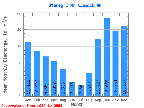
| Statistic | Jan | Feb | Mar | Apr | May | Jun | Jul | Aug | Sep | Oct | Nov | Dec | Annual |
|---|---|---|---|---|---|---|---|---|---|---|---|---|---|
| Mean | 13.12 | 10.93 | 9.55 | 8.39 | 6.54 | 3.41 | 2.66 | 5.61 | 13.73 | 18.66 | 15.76 | 16.76 | 10.35 |
| Standard Deviation | 4.72 | 7.51 | 3.77 | 3.32 | 3.69 | 1.61 | 1.45 | 3.91 | 5.81 | 5.66 | 6.75 | 8.57 | 2.31 |
| Min | 6.79 | 4.30 | 2.94 | 4.08 | 2.24 | 0.75 | 0.63 | 0.75 | 4.71 | 11.41 | 5.70 | 7.55 | 7.05 |
| Max | 22.16 | 27.84 | 16.00 | 15.83 | 15.81 | 7.13 | 5.67 | 13.29 | 25.44 | 31.80 | 28.21 | 35.96 | 15.07 |
| Coefficient of Variation | 0.36 | 0.69 | 0.40 | 0.40 | 0.56 | 0.47 | 0.55 | 0.70 | 0.42 | 0.30 | 0.43 | 0.51 | 0.22 |
 Return to R-Arctic Net Home Page