|
|
|||||||||||||||||
| Point ID: 9224 | Downloads | Plots | Site Data | Code: 15212000 |
|
|
|||||||||||||||||
| Download | |
|---|---|
| Site Descriptor Information | Site Time Series Data |
| Link to all available data | |
| View: | Time Series | All |
| Units: | mm |
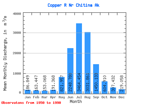
| Statistic | Jan | Feb | Mar | Apr | May | Jun | Jul | Aug | Sep | Oct | Nov | Dec | Annual |
|---|---|---|---|---|---|---|---|---|---|---|---|---|---|
| Mean | 186.85 | 163.45 | 153.07 | 191.37 | 821.96 | 2248.78 | 3464.45 | 3031.86 | 1450.13 | 604.91 | 307.43 | 219.06 | 1066.54 |
| Standard Deviation | 59.55 | 53.60 | 51.29 | 91.47 | 248.93 | 528.53 | 428.86 | 597.59 | 406.37 | 143.70 | 96.76 | 58.81 | 126.02 |
| Min | 76.45 | 65.13 | 56.63 | 84.95 | 436.17 | 1360.62 | 2390.58 | 1511.02 | 790.98 | 386.66 | 169.90 | 124.59 | 749.82 |
| Max | 337.98 | 336.77 | 323.36 | 548.40 | 1414.29 | 3255.49 | 4480.46 | 4551.70 | 2706.15 | 968.62 | 579.55 | 398.26 | 1397.30 |
| Coefficient of Variation | 0.32 | 0.33 | 0.34 | 0.48 | 0.30 | 0.23 | 0.12 | 0.20 | 0.28 | 0.24 | 0.32 | 0.27 | 0.12 |
 Return to R-Arctic Net Home Page