|
|
|||||||||||||||||
| Point ID: 9214 | Downloads | Plots | Site Data | Code: 15200000 |
|
|
|||||||||||||||||
| Download | |
|---|---|
| Site Descriptor Information | Site Time Series Data |
| Link to all available data | |
| View: | Time Series | All |
| Units: | mm |
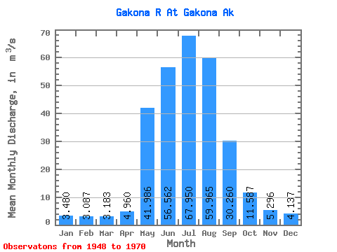
| Statistic | Jan | Feb | Mar | Apr | May | Jun | Jul | Aug | Sep | Oct | Nov | Dec | Annual |
|---|---|---|---|---|---|---|---|---|---|---|---|---|---|
| Mean | 3.48 | 3.09 | 3.18 | 4.96 | 41.99 | 56.56 | 67.95 | 59.97 | 30.26 | 11.59 | 5.30 | 4.14 | 24.95 |
| Standard Deviation | 1.98 | 1.74 | 1.89 | 3.06 | 19.39 | 19.96 | 13.82 | 15.89 | 14.36 | 5.05 | 2.68 | 2.25 | 4.82 |
| Min | 1.39 | 1.22 | 1.30 | 1.80 | 10.29 | 26.50 | 36.47 | 22.81 | 12.40 | 5.13 | 2.02 | 1.47 | 14.93 |
| Max | 7.93 | 7.36 | 7.08 | 12.71 | 94.72 | 111.05 | 101.13 | 91.72 | 74.40 | 22.36 | 10.95 | 8.49 | 36.98 |
| Coefficient of Variation | 0.57 | 0.56 | 0.59 | 0.62 | 0.46 | 0.35 | 0.20 | 0.27 | 0.47 | 0.44 | 0.51 | 0.54 | 0.19 |
 Return to R-Arctic Net Home Page