|
|
|||||||||||||||||
| Point ID: 9205 | Downloads | Plots | Site Data | Code: 15238648 |
|
|
|||||||||||||||||
| Download | |
|---|---|
| Site Descriptor Information | Site Time Series Data |
| Link to all available data | |
| View: | Time Series | All |
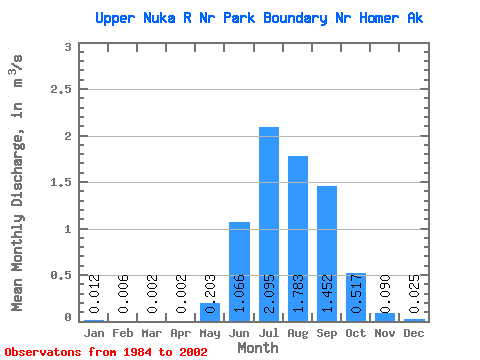
| Units: | mm |
| Statistic | Jan | Feb | Mar | Apr | May | Jun | Jul | Aug | Sep | Oct | Nov | Dec | Annual |
|---|---|---|---|---|---|---|---|---|---|---|---|---|---|
| Mean | 0.01 | 0.01 | 0.00 | 0.00 | 0.20 | 1.07 | 2.10 | 1.78 | 1.45 | 0.52 | 0.09 | 0.03 | 0.59 |
| Standard Deviation | 0.04 | 0.02 | 0.01 | 0.01 | 0.77 | 1.67 | 2.86 | 3.22 | 2.43 | 0.75 | 0.17 | 0.06 | 0.79 |
| Min | 0.00 | 0.00 | 0.00 | 0.00 | 0.00 | 0.02 | 0.08 | 0.03 | 0.05 | 0.00 | 0.00 | 0.00 | 0.02 |
| Max | 0.16 | 0.06 | 0.02 | 0.02 | 3.30 | 5.92 | 8.70 | 12.22 | 9.10 | 2.04 | 0.70 | 0.26 | 2.83 |
| Coefficient of Variation | 3.14 | 2.79 | 3.41 | 2.80 | 3.81 | 1.57 | 1.36 | 1.81 | 1.67 | 1.45 | 1.83 | 2.52 | 1.34 |
 Return to R-Arctic Net Home Page