|
|
|||||||||||||||||
| Point ID: 9199 | Downloads | Plots | Site Data | Code: 15225997 |
|
|
|||||||||||||||||
| Download | |
|---|---|
| Site Descriptor Information | Site Time Series Data |
| Link to all available data | |
| View: | Time Series | All |
| Units: | mm |
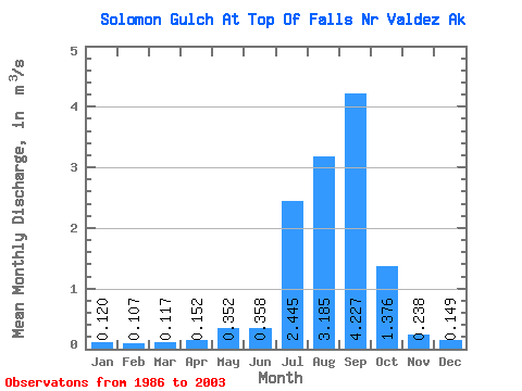
| Statistic | Jan | Feb | Mar | Apr | May | Jun | Jul | Aug | Sep | Oct | Nov | Dec | Annual |
|---|---|---|---|---|---|---|---|---|---|---|---|---|---|
| Mean | 0.12 | 0.11 | 0.12 | 0.15 | 0.35 | 0.36 | 2.44 | 3.19 | 4.23 | 1.38 | 0.24 | 0.15 | 1.09 |
| Standard Deviation | 0.08 | 0.06 | 0.11 | 0.07 | 0.12 | 0.49 | 2.57 | 2.42 | 3.43 | 1.97 | 0.41 | 0.09 | 0.63 |
| Min | 0.03 | 0.01 | 0.01 | 0.06 | 0.20 | 0.10 | 0.08 | 0.10 | 0.13 | 0.09 | 0.05 | 0.08 | 0.11 |
| Max | 0.32 | 0.24 | 0.50 | 0.38 | 0.72 | 2.02 | 6.35 | 8.41 | 9.56 | 6.48 | 1.79 | 0.32 | 2.17 |
| Coefficient of Variation | 0.63 | 0.52 | 0.90 | 0.46 | 0.34 | 1.36 | 1.05 | 0.76 | 0.81 | 1.43 | 1.70 | 0.57 | 0.58 |
 Return to R-Arctic Net Home Page