|
|
|||||||||||||||||
| Point ID: 9190 | Downloads | Plots | Site Data | Code: 15219000 |
|
|
|||||||||||||||||
| Download | |
|---|---|
| Site Descriptor Information | Site Time Series Data |
| Link to all available data | |
| View: | Time Series | All |
| Units: | mm |
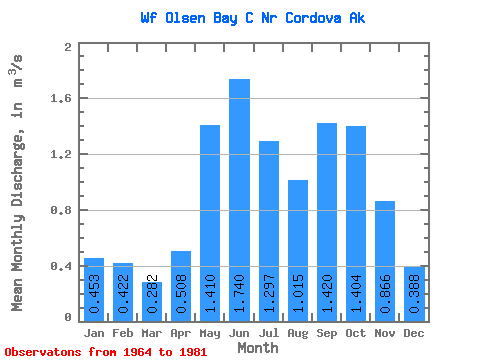
| Statistic | Jan | Feb | Mar | Apr | May | Jun | Jul | Aug | Sep | Oct | Nov | Dec | Annual |
|---|---|---|---|---|---|---|---|---|---|---|---|---|---|
| Mean | 0.45 | 0.42 | 0.28 | 0.51 | 1.41 | 1.74 | 1.30 | 1.01 | 1.42 | 1.40 | 0.87 | 0.39 | 0.93 |
| Standard Deviation | 0.67 | 0.57 | 0.26 | 0.24 | 0.23 | 0.41 | 0.47 | 0.54 | 0.82 | 0.52 | 0.90 | 0.32 | 0.16 |
| Min | 0.04 | 0.05 | 0.04 | 0.06 | 1.01 | 1.17 | 0.55 | 0.40 | 0.51 | 0.57 | 0.09 | 0.07 | 0.72 |
| Max | 2.21 | 2.14 | 0.73 | 1.00 | 1.88 | 2.77 | 2.33 | 2.12 | 3.09 | 2.30 | 3.92 | 1.12 | 1.28 |
| Coefficient of Variation | 1.47 | 1.35 | 0.91 | 0.48 | 0.17 | 0.24 | 0.36 | 0.53 | 0.58 | 0.37 | 1.04 | 0.82 | 0.17 |
 Return to R-Arctic Net Home Page