|
|
|||||||||||||||||
| Point ID: 9177 | Downloads | Plots | Site Data | Code: 15100000 |
|
|
|||||||||||||||||
| Download | |
|---|---|
| Site Descriptor Information | Site Time Series Data |
| Link to all available data | |
| View: | Time Series | All |
| Units: | mm |
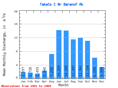
| Statistic | Jan | Feb | Mar | Apr | May | Jun | Jul | Aug | Sep | Oct | Nov | Dec | Annual |
|---|---|---|---|---|---|---|---|---|---|---|---|---|---|
| Mean | 1.90 | 1.74 | 1.46 | 2.34 | 7.23 | 14.22 | 14.05 | 11.50 | 11.94 | 11.11 | 6.09 | 3.40 | 7.30 |
| Standard Deviation | 1.23 | 1.21 | 0.84 | 0.73 | 1.93 | 2.49 | 2.03 | 1.88 | 4.00 | 3.67 | 2.16 | 2.04 | 0.65 |
| Min | 0.54 | 0.57 | 0.48 | 0.95 | 4.08 | 10.25 | 9.98 | 7.96 | 7.60 | 6.62 | 2.84 | 1.05 | 6.08 |
| Max | 4.98 | 5.55 | 4.02 | 3.50 | 10.55 | 18.73 | 17.17 | 15.32 | 22.07 | 19.08 | 11.36 | 7.94 | 8.54 |
| Coefficient of Variation | 0.65 | 0.70 | 0.57 | 0.31 | 0.27 | 0.17 | 0.14 | 0.16 | 0.34 | 0.33 | 0.35 | 0.60 | 0.09 |
 Return to R-Arctic Net Home Page