|
|
|||||||||||||||||
| Point ID: 9176 | Downloads | Plots | Site Data | Code: 15087700 |
|
|
|||||||||||||||||
| Download | |
|---|---|
| Site Descriptor Information | Site Time Series Data |
| Link to all available data | |
| View: | Time Series | All |
| Units: | mm |
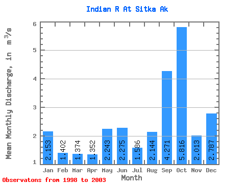
| Statistic | Jan | Feb | Mar | Apr | May | Jun | Jul | Aug | Sep | Oct | Nov | Dec | Annual |
|---|---|---|---|---|---|---|---|---|---|---|---|---|---|
| Mean | 2.15 | 1.40 | 1.37 | 1.35 | 2.24 | 2.27 | 1.59 | 2.14 | 4.27 | 5.82 | 2.01 | 2.79 | 2.55 |
| Standard Deviation | 0.79 | 0.77 | 0.99 | 1.06 | 1.20 | 0.94 | 0.34 | 1.95 | 1.79 | 1.18 | 0.61 | 2.27 | 0.42 |
| Min | 1.58 | 0.67 | 0.70 | 0.43 | 0.56 | 1.05 | 1.05 | 0.62 | 2.23 | 4.00 | 1.08 | 1.45 | 2.22 |
| Max | 3.53 | 2.34 | 3.03 | 3.05 | 3.93 | 3.69 | 1.92 | 5.55 | 6.36 | 7.02 | 2.48 | 6.81 | 3.15 |
| Coefficient of Variation | 0.37 | 0.55 | 0.72 | 0.79 | 0.53 | 0.41 | 0.22 | 0.91 | 0.42 | 0.20 | 0.30 | 0.82 | 0.16 |
 Return to R-Arctic Net Home Page