|
|
|||||||||||||||||
| Point ID: 9175 | Downloads | Plots | Site Data | Code: 15087545 |
|
|
|||||||||||||||||
| Download | |
|---|---|
| Site Descriptor Information | Site Time Series Data |
| Link to all available data | |
| View: | Time Series | All |
| Units: | mm |
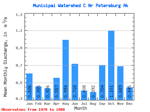
| Statistic | Jan | Feb | Mar | Apr | May | Jun | Jul | Aug | Sep | Oct | Nov | Dec | Annual |
|---|---|---|---|---|---|---|---|---|---|---|---|---|---|
| Mean | 0.61 | 0.46 | 0.44 | 0.56 | 0.99 | 0.72 | 0.41 | 0.39 | 0.70 | 1.10 | 0.69 | 0.45 | 0.62 |
| Standard Deviation | 0.41 | 0.30 | 0.20 | 0.19 | 0.31 | 0.27 | 0.15 | 0.24 | 0.42 | 0.45 | 0.42 | 0.28 | 0.09 |
| Min | 0.11 | 0.09 | 0.20 | 0.39 | 0.56 | 0.31 | 0.20 | 0.09 | 0.39 | 0.55 | 0.15 | 0.06 | 0.47 |
| Max | 1.43 | 1.14 | 0.76 | 1.03 | 1.58 | 1.27 | 0.71 | 0.84 | 1.58 | 1.77 | 1.38 | 0.93 | 0.73 |
| Coefficient of Variation | 0.68 | 0.66 | 0.45 | 0.34 | 0.31 | 0.38 | 0.37 | 0.62 | 0.60 | 0.41 | 0.61 | 0.62 | 0.15 |
 Return to R-Arctic Net Home Page