|
|
|||||||||||||||||
| Point ID: 9162 | Downloads | Plots | Site Data | Code: 15129500 |
|
|
|||||||||||||||||
| Download | |
|---|---|
| Site Descriptor Information | Site Time Series Data |
| Link to all available data | |
| View: | Time Series | All |
| Units: | mm |
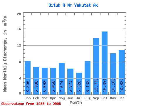
| Statistic | Jan | Feb | Mar | Apr | May | Jun | Jul | Aug | Sep | Oct | Nov | Dec | Annual |
|---|---|---|---|---|---|---|---|---|---|---|---|---|---|
| Mean | 8.21 | 6.79 | 6.59 | 6.46 | 7.67 | 6.37 | 5.33 | 8.13 | 13.77 | 15.39 | 10.10 | 10.83 | 8.83 |
| Standard Deviation | 3.84 | 3.17 | 3.68 | 2.32 | 2.23 | 1.71 | 1.62 | 4.38 | 4.82 | 5.34 | 3.88 | 5.70 | 1.41 |
| Min | 3.70 | 2.30 | 1.54 | 2.08 | 4.54 | 3.59 | 2.20 | 2.98 | 7.38 | 8.01 | 4.91 | 4.01 | 6.32 |
| Max | 17.56 | 13.33 | 14.61 | 10.49 | 11.85 | 9.77 | 8.26 | 17.34 | 23.74 | 24.86 | 16.94 | 20.93 | 11.30 |
| Coefficient of Variation | 0.47 | 0.47 | 0.56 | 0.36 | 0.29 | 0.27 | 0.30 | 0.54 | 0.35 | 0.35 | 0.38 | 0.53 | 0.16 |
 Return to R-Arctic Net Home Page