|
|
|||||||||||||||||
| Point ID: 9154 | Downloads | Plots | Site Data | Code: 15106980 |
|
|
|||||||||||||||||
| Download | |
|---|---|
| Site Descriptor Information | Site Time Series Data |
| Link to all available data | |
| View: | Time Series | All |
| Units: | mm |
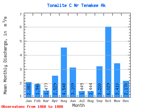
| Statistic | Jan | Feb | Mar | Apr | May | Jun | Jul | Aug | Sep | Oct | Nov | Dec | Annual |
|---|---|---|---|---|---|---|---|---|---|---|---|---|---|
| Mean | 2.08 | 1.95 | 1.48 | 2.53 | 4.55 | 3.11 | 1.45 | 1.44 | 3.20 | 6.03 | 3.41 | 2.17 | 2.77 |
| Standard Deviation | 1.85 | 1.64 | 0.89 | 0.92 | 1.51 | 1.48 | 0.61 | 0.85 | 1.58 | 2.71 | 1.89 | 1.48 | 0.41 |
| Min | 0.29 | 0.28 | 0.47 | 0.87 | 1.79 | 0.96 | 0.47 | 0.40 | 0.92 | 2.52 | 0.73 | 0.40 | 2.11 |
| Max | 6.14 | 5.80 | 3.64 | 4.28 | 8.09 | 6.32 | 2.65 | 3.80 | 8.11 | 14.03 | 5.95 | 5.86 | 3.53 |
| Coefficient of Variation | 0.89 | 0.84 | 0.60 | 0.36 | 0.33 | 0.48 | 0.42 | 0.59 | 0.49 | 0.45 | 0.55 | 0.68 | 0.15 |
 Return to R-Arctic Net Home Page