|
|
|||||||||||||||||
| Point ID: 9144 | Downloads | Plots | Site Data | Code: 15106100 |
|
|
|||||||||||||||||
| Download | |
|---|---|
| Site Descriptor Information | Site Time Series Data |
| Link to all available data | |
| View: | Time Series | All |
| Units: | mm |
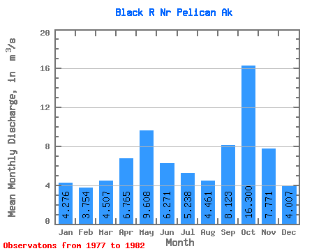
| Statistic | Jan | Feb | Mar | Apr | May | Jun | Jul | Aug | Sep | Oct | Nov | Dec | Annual |
|---|---|---|---|---|---|---|---|---|---|---|---|---|---|
| Mean | 4.28 | 3.75 | 4.51 | 6.76 | 9.61 | 6.27 | 5.24 | 4.46 | 8.12 | 16.30 | 7.77 | 4.01 | 7.07 |
| Standard Deviation | 3.81 | 2.72 | 1.61 | 2.94 | 3.11 | 1.97 | 1.22 | 1.62 | 3.37 | 5.00 | 2.11 | 2.10 | 0.77 |
| Min | 1.07 | 0.51 | 2.41 | 4.32 | 4.10 | 2.76 | 3.56 | 3.13 | 5.35 | 10.95 | 4.32 | 1.74 | 6.16 |
| Max | 10.87 | 7.04 | 6.61 | 11.64 | 11.54 | 7.32 | 6.95 | 6.25 | 13.89 | 24.16 | 9.42 | 6.40 | 7.84 |
| Coefficient of Variation | 0.89 | 0.72 | 0.36 | 0.43 | 0.32 | 0.31 | 0.23 | 0.36 | 0.41 | 0.31 | 0.27 | 0.53 | 0.11 |
 Return to R-Arctic Net Home Page