|
|
|||||||||||||||||
| Point ID: 9136 | Downloads | Plots | Site Data | Code: 10OB001 |
|
|
|||||||||||||||||
| Download | |
|---|---|
| Site Descriptor Information | Site Time Series Data |
| Link to all available data | |
| View: | Time Series | All |
| Units: | mm |
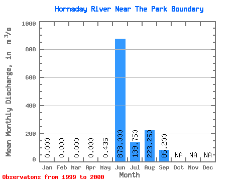
| Statistic | Jan | Feb | Mar | Apr | May | Jun | Jul | Aug | Sep | Oct | Nov | Dec | Annual |
|---|---|---|---|---|---|---|---|---|---|---|---|---|---|
| Mean | 0.00 | 0.00 | 0.00 | 0.00 | 0.43 | 878.00 | 139.75 | 223.25 | 85.20 | ||||
| Standard Deviation | 0.62 | 155.56 | 103.59 | 283.90 | |||||||||
| Min | 0.00 | 0.00 | 0.00 | 0.00 | 0.00 | 768.00 | 66.50 | 22.50 | 85.20 | ||||
| Max | 0.00 | 0.00 | 0.00 | 0.00 | 0.87 | 988.00 | 213.00 | 424.00 | 85.20 | ||||
| Coefficient of Variation | 1.41 | 0.18 | 0.74 | 1.27 |
 Return to R-Arctic Net Home Page