|
|
|||||||||||||||||
| Point ID: 9118 | Downloads | Plots | Site Data | Code: 05AC928 |
|
|
|||||||||||||||||
| Download | |
|---|---|
| Site Descriptor Information | Site Time Series Data |
| Link to all available data | |
| View: | Time Series | All |
| Units: | mm |
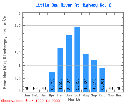
| Statistic | Jan | Feb | Mar | Apr | May | Jun | Jul | Aug | Sep | Oct | Nov | Dec | Annual |
|---|---|---|---|---|---|---|---|---|---|---|---|---|---|
| Mean | 0.75 | 1.64 | 2.13 | 2.46 | 1.43 | 1.19 | 0.90 | ||||||
| Standard Deviation | 0.03 | 0.12 | 0.54 | 0.05 | 0.37 | ||||||||
| Min | 0.73 | 1.55 | 1.75 | 2.42 | 1.17 | 1.19 | 0.90 | ||||||
| Max | 0.77 | 1.72 | 2.51 | 2.49 | 1.69 | 1.19 | 0.90 | ||||||
| Coefficient of Variation | 0.04 | 0.07 | 0.25 | 0.02 | 0.26 |
 Return to R-Arctic Net Home Page